
Click Above To Access My Blog
This blog grew out of a desire to share with others my enthusiasm for getting to know my neighbourhood and my city – and hopefully more parts of South Africa and beyond!
The Cape Peninsula is an extraordinarily beautiful place: we have an iconic world-famous mountain right in the heart of Cape Town, wonderful and easily accessible hiking trails all over the mountain, and a fascinating history, culture and society just waiting to be explored.
Hover your mouse over each of the menus at the top of the screen (Exploring the Cape, Getaways, Hikes and Rambles, Travel, Home and Garden, Entertainment and Defence Reserves) to access archived posts in those categories.
Happy Browsing!
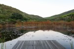
Below, to get you started, are links to some of my favourite posts and categories. Click on any of the photos to explore further:
 My Book |
 Exploring the Cape |
 Hikes & Rambles |
 Cape Town Military Tattoo |
 Getaway to the Garden Route |
 Getaway to the Cedarberg Mountains |
 Getaway to the Olifants River Mountains |
 Getaway to Swellendam |
 Getaway to McGregor |
 Getaway to Stanford |
 Getaway to Riversdale |
 Getaway to Bodhi Khaya |

As always so wonderful
I love these pictures!
You have a lovely blog! Look forward to reading many of your posts:)
Thank you so much for such a kind comment, Rashmi. I hope you enjoy reading them. And I wish you all the best of luck and much success with your own blog!
I’ve been in South Africa last spring and lived in Lakeside. I hiked through Silvermine, saw many unforgettable pictures. That is all deep in my heart and thanks for your blog – refreshing of our memories.